Back Most Čínsko-korejského přátelství Czech Den kinesisk-koreanske venskabsbro Danish Chinesisch-koreanische Freundschaftsbrücke German Puente de la Amistad Sinocoreana Spanish Sino-Korear Anaiartearen zubia Basque Pont de l'amitié sino-coréenne French גשר הידידות הסינו-קוריאני HE चीन-कोरिया मैत्री पुल Hindi Jembatan Persahabatan Tiongkok-Korea ID Ponte dell'Amicizia sino-coreana Italian
Sino-Korean Friendship Bridge | |
|---|---|
 The bridge (on left side) viewed from Dandong, China. The Yalu River Broken Bridge is to its right. | |
| Coordinates | 40°6′54″N 124°23′33″E / 40.11500°N 124.39250°E |
| Carries | One lane of |
| Crosses | Amnok River |
| Locale |
|
| Official name |
|
| Other name(s) | Sino-Korean or China–Korea Friendship Bridge |
| Characteristics | |
| Material | Steel |
| Total length | 940.8 m (3,087 ft) |
| History | |
| Construction start | April of 1937 |
| Construction end | May of 1943 |
| Location | |
 | |
| Sino-Korean Friendship Bridge | |||||||||||||||||
|---|---|---|---|---|---|---|---|---|---|---|---|---|---|---|---|---|---|
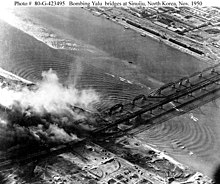
 Aerial photograph taken in November of 1950 during air attacks by US Air Force bombers, with damage to the two Amnok River bridges showing. | |||||||||||||||||
| Chinese name | |||||||||||||||||
| Simplified Chinese | 中朝友谊桥 | ||||||||||||||||
| Traditional Chinese | 中朝友誼橋 | ||||||||||||||||
| |||||||||||||||||
| Korean name | |||||||||||||||||
| Chosŏn'gŭl | 조중우의교 | ||||||||||||||||
| Hancha | 朝中友誼橋 | ||||||||||||||||
| |||||||||||||||||
The Sino-Korean Friendship Bridge, or China–North Korea Friendship Bridge, is a bridge across the Yalu or Amnok River on the China–North Korea border. It connects the cities of Dandong in China and Sinuiju of North Korea, by railway and roadway but pedestrians are not allowed to cross between either side. The bridge serves as one of the few ways to enter or leave North Korea.
It was renamed to its current name from the Yalu (Amnok) River Bridge in 1990. The bridge was constructed by the Imperial Japanese Army (IJA) between April 1937 and May 1943 during its occupation of Korea and its puppet state of Manchukuo (now northeast China). Further downstream, construction work on the New Yalu River Bridge began in October 2010.
© MMXXIII Rich X Search. We shall prevail. All rights reserved. Rich X Search